“Big Cold Weather Pattern Change” Forecasted For Eastern US
The weather blog Severe Weather Europe provides an in-depth analysis of “cold anomalies across much of the central, southern, and eastern United States” after the start of the new year.
The influence of the El Nino continues to grow, helping to create a strong Jet Stream pattern over the Pacific Ocean, bringing warmth into North America. But a pattern change is still on course for January.https://t.co/iD0a8DTm2e
— severe-weather.EU (@severeweatherEU) December 14, 2023
This news should excite our US readers since many of them have been experiencing higher-than-average temperatures due to El Niño.
* * *
Authored by Andrej Flis of Severe Weather Europe,
Winter 2023/2024 has begun in a very dynamic way. Currently, we have a strong train of pressure waves across the Pacific and into North America. That will evolve into a strong low-pressure system, driving a powerful jet stream and warmer air over the United States, just to be replaced in early 2024 by a big cold weather pattern change.
A low-pressure area is forecast to develop over the North Pacific in the next few days and will produce a strong jet stream pattern that will push the mild ocean air into North America. But it is not forecast to last long, as proper winter is currently scheduled to arrive in January.
We will first look at the latest weather patterns and the unusual jet stream development forecast. You will also see how Winter is forecast to arrive in January, and we will also look at what is driving the atmosphere from one extreme to the other.
WAVES IN THE ATMOSPHERE
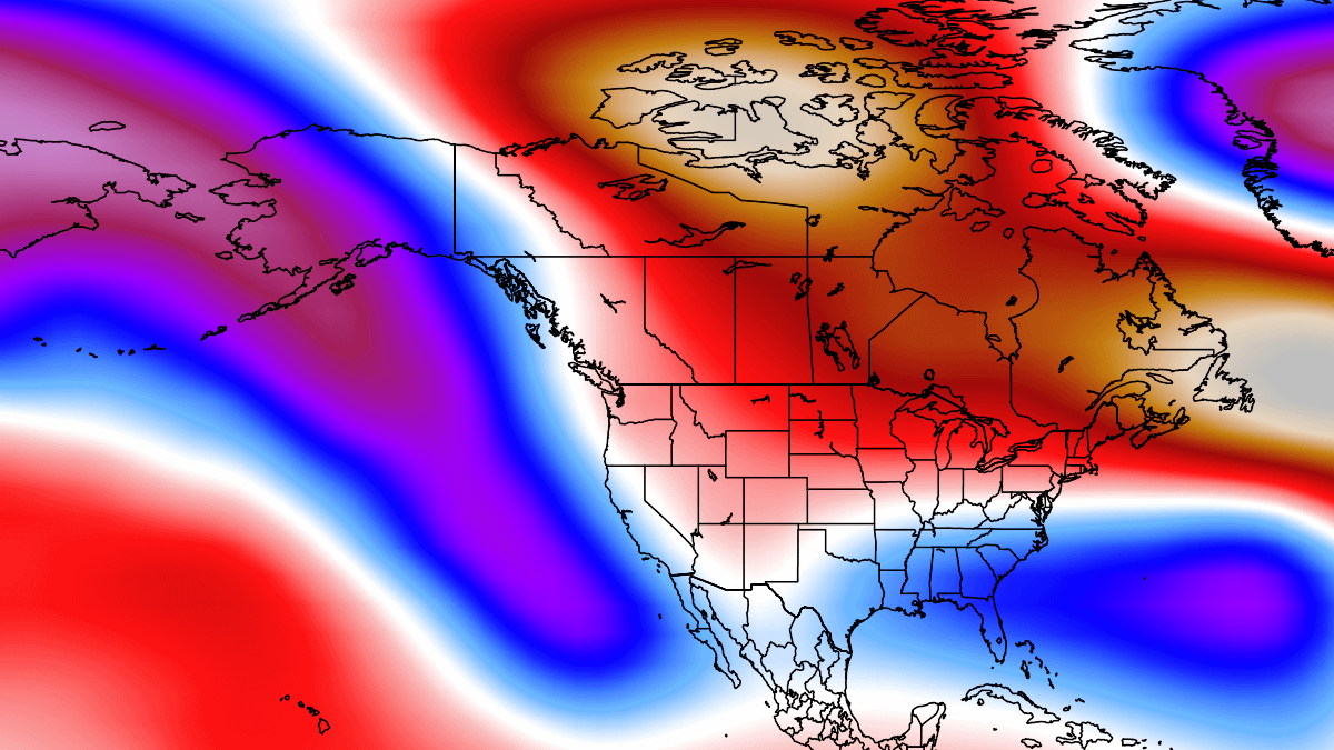
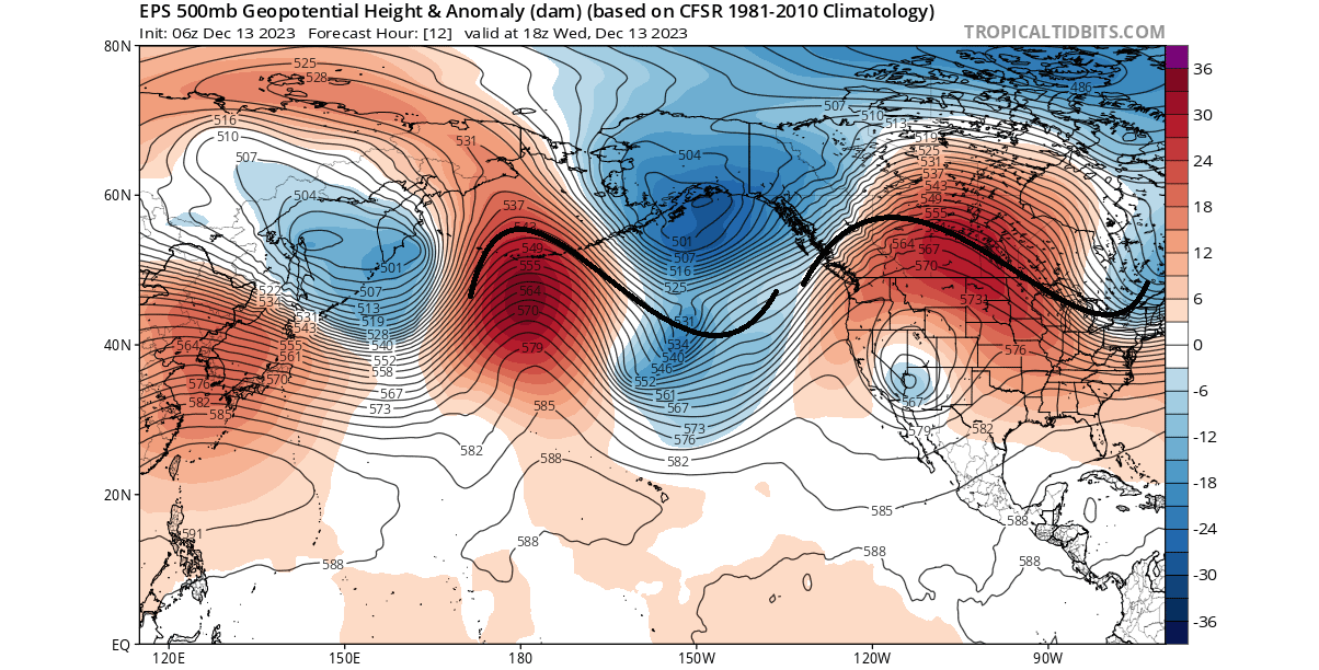
The current weather pattern across the North Pacific and North America is very dynamic. In the image below, you can see the latest pressure anomalies in a wave-like pattern. Such pressure waves are an attempt of the atmosphere to balance out the temperature difference between the cold poles and the warm tropics.
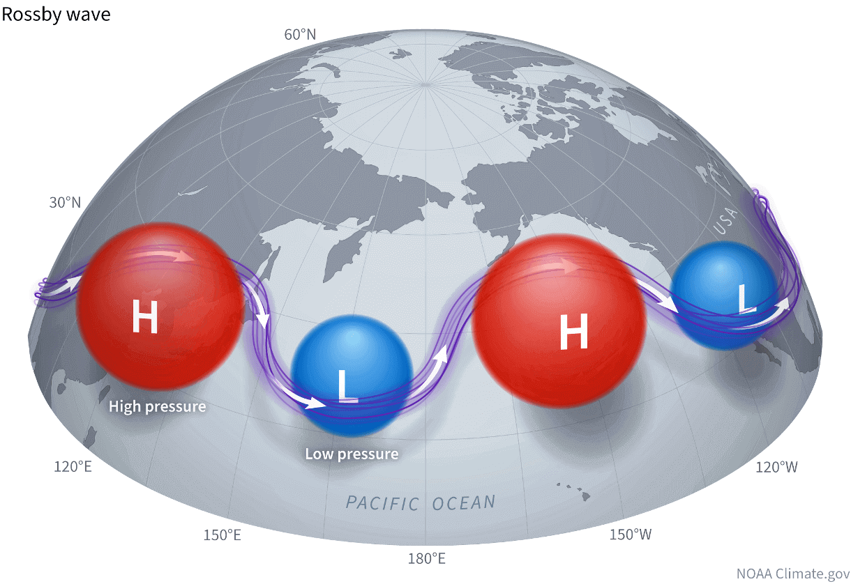
These pairs of pressure systems are also known as Rossby Waves. You can see an example of Rossby waves in the image below by NOAA. As you can see, the current pattern above is quite a textbook example of a Rossby wave train from the Pacific into North America.
The violet line connecting these pressure systems is the jet stream. It drives and interacts with the pressure systems, thus helping to directly influence our daily weather. That is why any changes in the jet stream are very important to monitor.
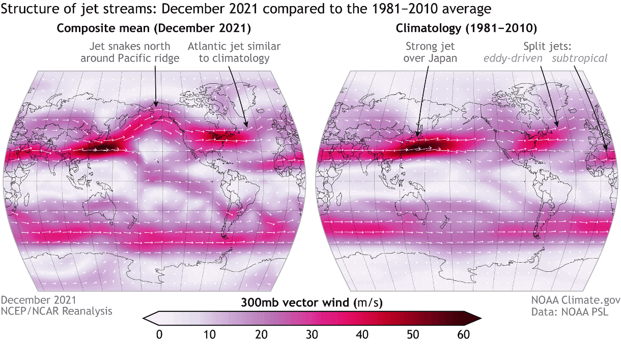
The term jet stream is behind extreme events, from cold spells and flooding to heatwaves and droughts. It is a fast, narrow current of air flowing from west to east that surrounds the globe. In the image below, you can see an example of the global jet stream in a NOAA analysis.
This all comes together if we look at the latest temperature anomalies across the Pacific and North America. Just like with pressure anomalies, you can see the temperature waves of warm and cold zones. As a warm anomaly is present over the northern United States and Canada, a colder-than-normal anomaly is over the northeastern United States.
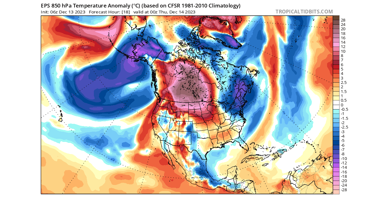
These temperature patterns directly correspond to the high and low-pressure systems and the jet stream that connects them. The strongest cold is usually found when the jet stream is wavy, and these pressure waves are strong, and the low-pressure area of the wave is directly over the United States.
But there is a reason why we are looking at the current pattern and learning about pressure waves and the jet stream.
In the coming days, the dynamic waves in the North Pacific will be replaced by a large and strong low-pressure area, creating a more linear jet stream and having a strong weather impact over the United States and Canada.
AS THE PRESSURE DROPS
During winter, the pressure systems tend to be stronger, especially lows. As there is a lot of energy involved, the weather systems are constantly in motion and interacting with each other. This can bring along pattern changes on a larger scale, one like we are about to see unfold in the second half of December.
The graphics below show the ensemble forecast from the ECMWF data, openly available by the Copernicus data hub. Images are provided by weathermodels.com, using a commercial license.
Looking 10 days ahead, you can see in the forecast below that a broad low-pressure area is forecast to develop over the Aleutians. This will replace the usual train of shorter pressure waves and produce a more linear pattern.
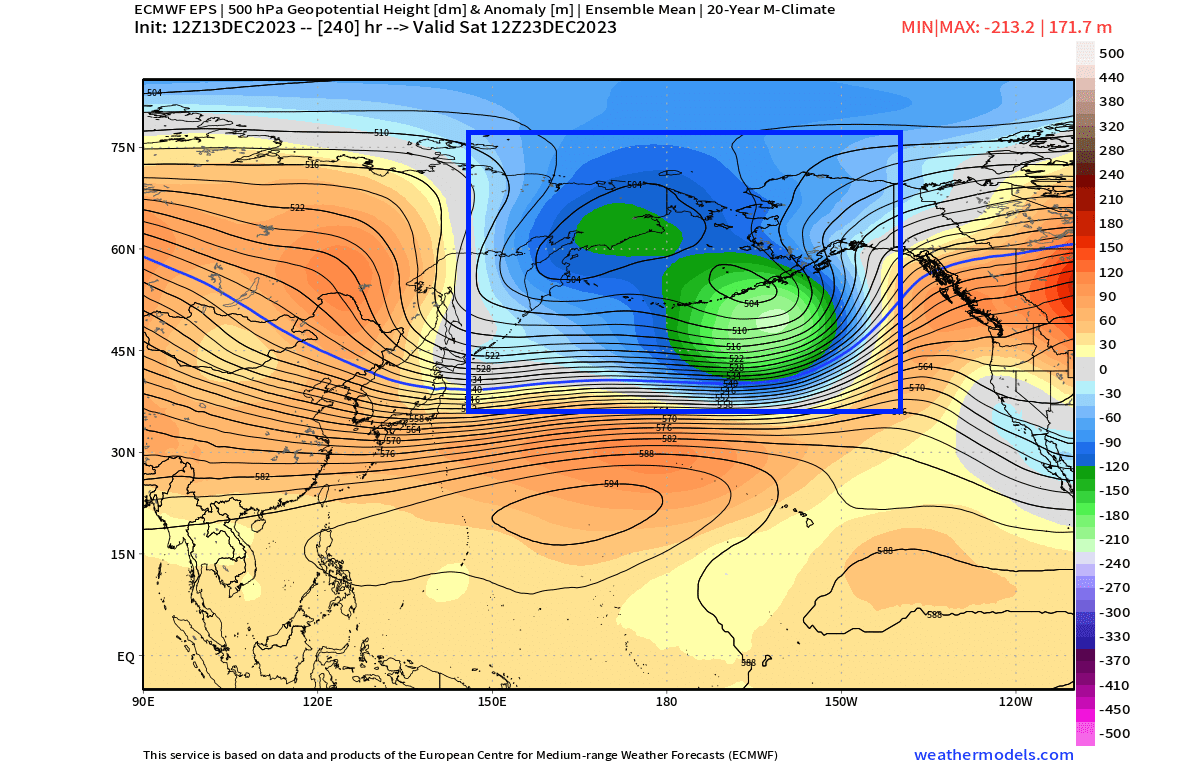
This longer wave pattern can be seen in the forecast below for the holidays. You can see a broad low-pressure area over the ocean and a large high-pressure area over North America. This is the same Rossby wave pattern as you saw in the beginning, but in a longer form.
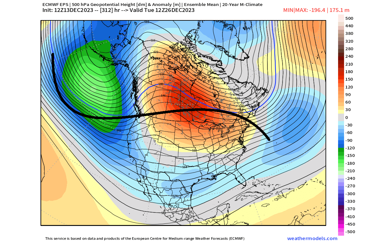
What this does is two things. First, it creates a strong pressure difference. And strong pressure difference means strong winds. This brings strong westerly and southwesterly low-level winds into the western United States and western Canada and, with it, milder ocean air.
READ MORE HERE
Share This Story, Choose Your Platform!

About the Author: Patriotman


GUNS N GEAR


