
Badlands Fieldcraft: Proper Planning for Field Excursions: part 2
This originally appeared on Badlands Fieldcraft. NCS
In part one I discussed commander’s intent, backwards planning, and the XYT. I encourage you to read that article if you haven’t had a chance to already. For those of you with experience in military planning and wondering why I’m not getting into the more doctrinal aspects of planning, I’ll get there. I want to first discuss tools I’ve learned that are used on a more day to day basis and that augment more doctrinal techniques, you might say they’re unconventional. I’ve been taught the “top down” view of planning many times, what I’d like to do is present it from the bottom up instead.
The next three ideas I’d like to discuss are the map study, OCOKA-W and the rule of threes.
Once we have been either given a task to complete or developed one ourselves, we should begin familiarizing ourselves with the terrain or area we will be operating in. The more information sources you can tap into the better.
As of this writing Google earth is still available and is a great resource for studying terrain. There are a few features I find very useful and I think you will too. First is the 3D terrain setting, you want to ensure this is on when you are doing a terrain study. This will give you a fairly good idea of the general terrain in an area, and with the capability to go to ground level it can give you a pretty realistic sense of what you’ll see terrain wise in an area. One thing to note is foliage and structures are not taken into account all the time.

Next is the viewshed calculator. Once you’ve set a specific waypoint you can right click on it and calculate the field of view for that waypoint. It will ask you from what elevation as well, and you can play with this to get a good idea of what kind of line of sight you’ll have at different elevations. This is useful for a lot of purposes but I’ll leave you to your imagination.

The next tool that is useful is that you can adjust the visible light to a certain time of day. While this doesn’t account for man made illumination or moonlight, it can give an idea of what areas are illuminated at different times of day. Once again, I’ll leave this up to you to figure out how best to use it.
While Earth is a good tool, it’s not the only tool available. I would advise you to screenshot and save/print any pertinent information from there for future use though.
The next tool available is the free PDF maps from the USGS website. These are multilayered maps with a traditional topographical map as well as a satellite view that can be overlaid. While not in 3D like Earth, it is still a very good resource. I once again advise saving and printing any pertinent map sheets that you may want in the future.
The next tool available is any Open Source Intelligence that is available about your area of interest. This could be photos, videos and articles online to published magazines or other documents. Also don’t discount first hand accounts from people familiar with the area and then of course there is always the option to scout it yourself…
So besides familiarizing ourselves with an area, what are we looking for when we are doing a map study? For those of us with a degree from USMC and similar schools, we use an acronym OCOKA-W. It stands for Observation and fields of fire, Cover and concealment, Obstacles, Key terrain, Avenues of Approach and Weather. We want to look at these different aspects from both our point of view as well as the point of view of any other parties involved, whether they are friend or foe. For example, for Observation, what sort of observation will the terrain allow for? How far can you see on average based on the terrain and vegetation? How will this effect you and your adversary?
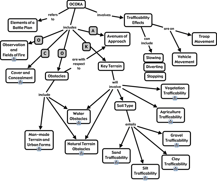
The different factors of OCOKA-W are also dependent on each other. For instance, once a key terrain feature, in this case a hill top, is identified, what will the Observation and fields of fire look like for it in good weather and bad weather? How about at night? Is there any dead space in those fields of fire?
Dead space is an area within a field of fire that cannot be observed or covered by a direct fire weapon and should be considered a key terrain feature as well. Any feature whether man made or natural that has the capability to impact your actions or your enemies is considered key terrain. Some examples of these are hilltops, tall buildings, ditches, rivers, wadis or forests.

Avenues of Approach are any obvious routes into or away from an area. These can be roads, trails, or other features such as a right of way through a forest. Avenues of approach can be further classified into “high speed” and “low speed”. For instance, if it rains on the power line right of way, how will that effect our ability to move through that Avenue of Approach? It might go from high speed to low speed. From a defensive point of view, this equates into how much reaction time I have to prevent someone from moving down that road into my area. It might dictate that I need to employ Obstacles, another OCOKA-W consideration. From an offensive point of view, it might dictate how I can move through an area and what sort of equipment and training I’ll need.
While not a part of OCOKA-W, I also take note of what natural resources are in the area. What kind of vegetation is there? Where can I get water should I need to? What kind of game or edible plants are available this time of year? How best can I camouflage myself in the area?
The next planning tool I’d like to discuss is “The rule of threes”. While I’m not aware if there’s actually a published definition for it, it’s simply the concept of not giving a person more than three responsibilities at a time.

In a leadership sense, it means not giving any leader more than three charges to supervise. This of course isn’t a hard rule, but the idea is not to have so much resting on one man’s shoulders. Spread the workload and the stress out so that each of the individual jobs will get done better. While in the civilian world it’s not uncommon to see people managing much more than that, there’s a big difference between civilian management and combat leadership.
Incoming rant… They aren’t even on the same planet. At a time in life when most civilian managers are still figuring out what to do with their manhood, most combat leaders are making multiple life and death decisions a day in an environment where you have to make do with the people you have. No HR to handle non-performers. They have to be motivated to do their jobs and it’s up to the leader to figure out how. Rant over…
So back to the “Rule of threes”. If I’m the one planning I want to ensure the best I can that I’m not trying to do everything. Sometimes a leader tends to get “leader’s legs” and will want to run around and do everything himself. This is no good in the long run. If I have ten other people in my group I can’t do everything for all of them; I need to be able to delegate certain tasks to other people. I also can’t supervise and inspect everything that needs done, so that too needs delegated. Those three words are italicized for a reason; delegate appropriate tasks to the appropriate person, supervise, and inspect what you expect.
So starting from the ground up, you have one man, just a leader without a team. Then as his team grows, he will become a team leader. Eventually the team gets big enough to split, making two teams. At this point the original man, if he’s the best man for the job, should take a more supervisory role and there should be two team leaders overseeing the teams. Eventually as the teams grow, it will become time to split them and create a second squad. In this way, no matter what there’s always a leader, even if it’s just one man by himself.

Share This Story, Choose Your Platform!

About the Author: NC Scout
15 Comments
Comments are closed.

Related Posts


Howitzer Clothing – Code AP15 for 15% OFF


CIVIL DEFENSE MANUAL – Only $56.29 This Month!


GUNS N GEAR


5
Great Post JJ!
Don’t forget to mention setting your watches to the same time!
I keep multiple watches on my wrist, kit, and bag.
Just in case some needs one.
The $20 Casio from Walmart is probably the best one.
4
The Patriot community seems frozen in a Rural Comflict approach.
I want to be able to hit targets without getting caught. Most of the targets are going to be in metropolitan areas.
They are for now.
You should listen to my interview with Glenn Tate.
holy fuck, yes.
So I suppose that means proper mission planning doesn’t apply?
If that response is to me, no, not at all what I’m saying. I’m thinking the cities are the power centers. Boston to DC is basically one big city. most mid-sized cities away from the northeast are also predominantly leftist. Cities have most of the money, most of the big ones are coastal and have massive transportation infrastructure. They are loaded with people. They can raise armies if they want. They’ll find people to train them. They might not be the highest quality armies, but they will be large groups of armed individuals/thugs. Hell, they could offer them spoils of war as reward for their “conquests”. They wont attack ALL the rural areas at once. They can pick areas, individually, and ravage them – one area at a time. There probably wont be enough resistance to fight them in those areas.
Most of all, the major media centers and tech centers are in the cities. Without them, we wouldn’t be in the situation we are in, in this country. A LOT of people have been fleeced and they are eating every bit of it up. I’m sure everyone reading this has people they know, friends and family even who buy every bit of propaganda served up. It is largely because of media and tech. Media and tech are the cool kids. Of course you want to be with the cool kids.
I’m just thinking that to avoid constant defensive conflict, there would be a need to inflict damage on them. Hypothetically, of course.
Mike, below, definitely makes excellent points. The rural areas need to be secured, there are leftists in every area and region. But the cities will probably have to be swayed eventually. Somehow. I don’t believe they will just whither and die because of internal problems. I don’t think there is any historical precedent for it.
Of course planning will be just as important as ever.
From what I’ve seen, most of the training and talk has been of rural conflict. I believe urban operations should be considered more.
It wasn’t to you.
Target any highway, bridge, railway, water and power access to any large city. Just one will cause major havoc. Infrastructure, traffic, utilities. Any team that has their shit tight and conducted PE can make any metro area grind to a halt. Cities are killing fields in the making.
As I see it, you have to secure your rear area’s first. For most Heritage Americans that is rural, or at least not the big blue cities.
If the situation in the big cities becomes unstable and conditions deteriorate, the ability of the enemy to be secure in them will become problematic, even though they have a supportive population residing there. When the power goes out, the groceries and goods stop flowing, etc, the merry cohesive band of team big blue will start to break down as they start competing with each other for resources. The trained mobs they set loose in the streets all Summer will reform without the key political leadership that kept them focused an a specific political message and will act in self interest. I predict the irreconcilable social differences between elements of that street army will come to the fore at that point and they will engage in blue on blue intramurals. The cities should all devolve into Mogadishu type smoldering ash heaps before too long and the official big blue authorities would likely be reduced to holding a few fortified strongpoints and exercising control over not much else. I think it is likely that much if not most of this projected damage to their own core areas will be self inflicted. None of this means that there cannot be conflict in the rural areas between the 2 main factions, I expect that and think winning that fight and worrying about the cities last is the way to go. I can see no logic in taking a rural self defense force away from it’s home ground (even if they were willing to go, a big if), and trying to accomplish something in or near a big blue metro area 40, 60, or 100 miles away. If some on our team are much closer than that and have the local numbers to sustain something, then obviously there is a need for a MOUT capability for the friendlies taking on those tasks. I just don’t see it as a practical reality for most of what shows up for our side. Again, just my opinion, but I would be happy to discuss it further.
Staying in your AO confers a tremendous advantage. One of the best Selous Scout trackers said if he was to operate in a different environment he would lose 40% of the advantage he held from years in the local bush. Living in the Rocky mountains for over 40 years, and hunting and hiking daily shifts the advantage greatly to me. I easily spot deer and other wildlife at 500-1000 yards away by just being familiar with the terrain features and colors of the season. People from the city can’t see a deer standing in an open field at 200 yards.
So couple this advantage with a nice semiautomatic 308 and good scope and NODs and how is that going to work out for the city folk coming to “invade”?
There will be plenty going rural when the shities break down. Think like a noble for a minute. They have three or four houses and maybe a McMansion cabin on a lake or in Sun Valley, Idaho. I found a Clinton croney,state dept cia USAID high level deep stater just bought 5 acres up near Stanly , Idaho on a USFS road with access only in the summer or snow machine into it in the winter. Last address Washington DC.
Very odd she purchased it right after the big Allen & Company event they have here in Sun Valley each year. The deep state trash will try to blend in but only where they feel safe when SHTF.
@Bull; They won’t be hard to spot. They tend to congregate in specific high end areas of the planet among their fellow elitists with the assets and security on display. Problem for them is selecting the right well to drink out of that they have not poisoned, They also need to keep the private army paid and fed.
There are a few of these historic elite hangouts in my neck of the woods. They will not be a priority until the rank and file locals are sorted out.
I like these two articles. Looking forward to more. If anyone has an issue running Google Earth, might I suggest Hawg-view (hawg-ops.com)? Its mainly used by A-10 pilots, among other aviators, to make unclassified scenarios using Google Earth , but it may have some utility in other scenarios since you can draw shapes and plot other things.